Turn any route into an immersive digital trail experience.
A browser-based virtual guide that you own on your website. Audio and visual guides, multi-layer pin maps, dark mode, multiple locations, and a full admin portal. Users get the app with no app store and no downloads.
Two live deployments show how the same app adapts to very different settings — a town-centre heritage trail and a rural farm walk. Both are running the exact same code base, just configured differently. Tap either screenshot to open the working app on your phone. And since v4.4.0, one installation can even serve both kinds of location at once — visitors swap between maps with the built-in Switch Map button.
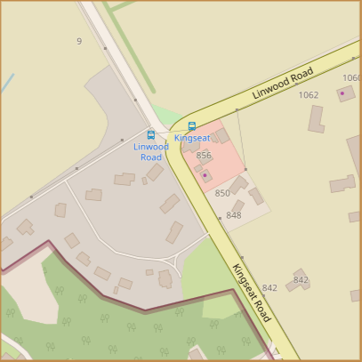
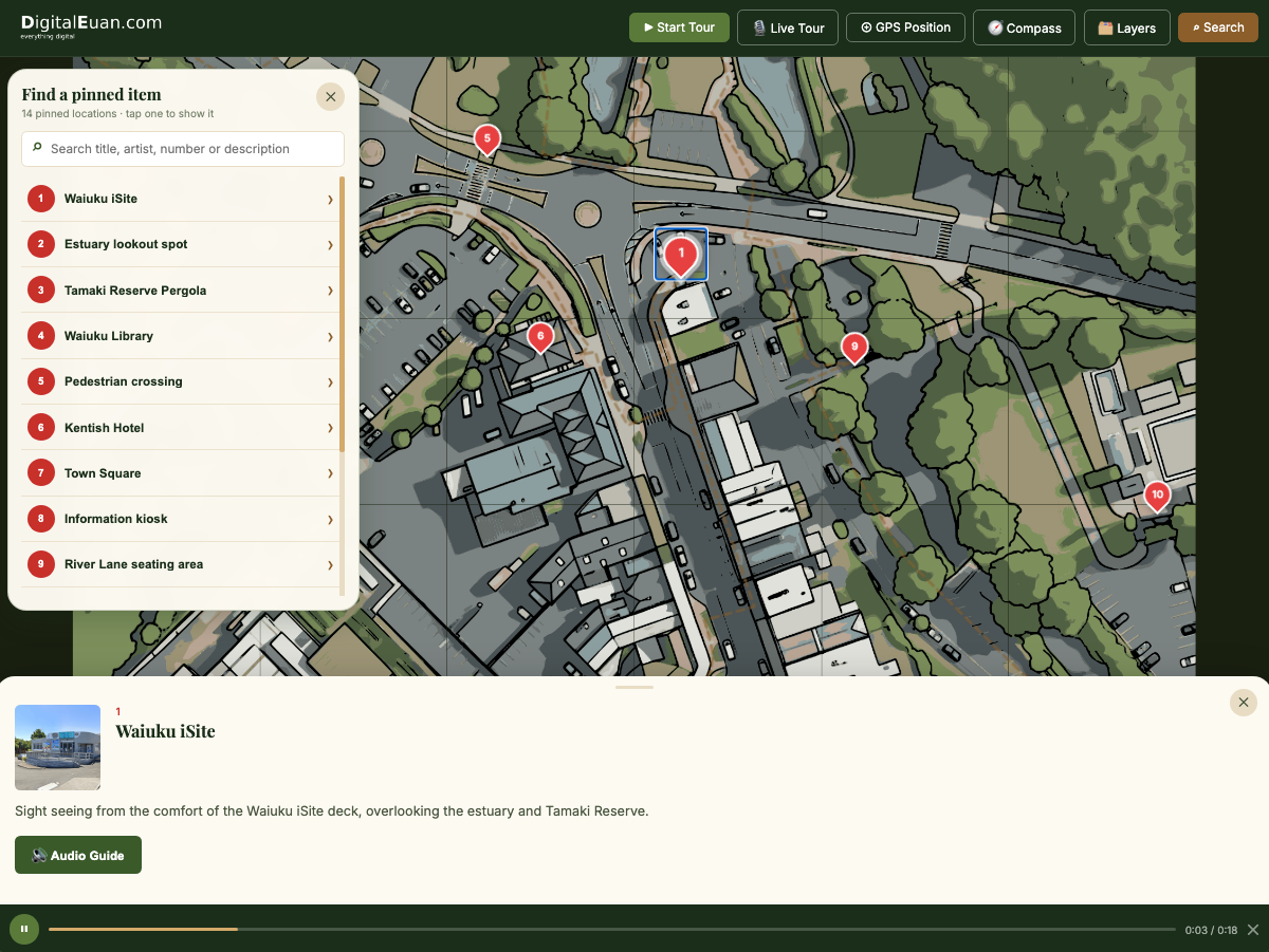
A guided trail through Waiuku town centre — showing how the same app handles narrow streets, mixed-use mapping, and self-guided tours for visitors arriving on foot.
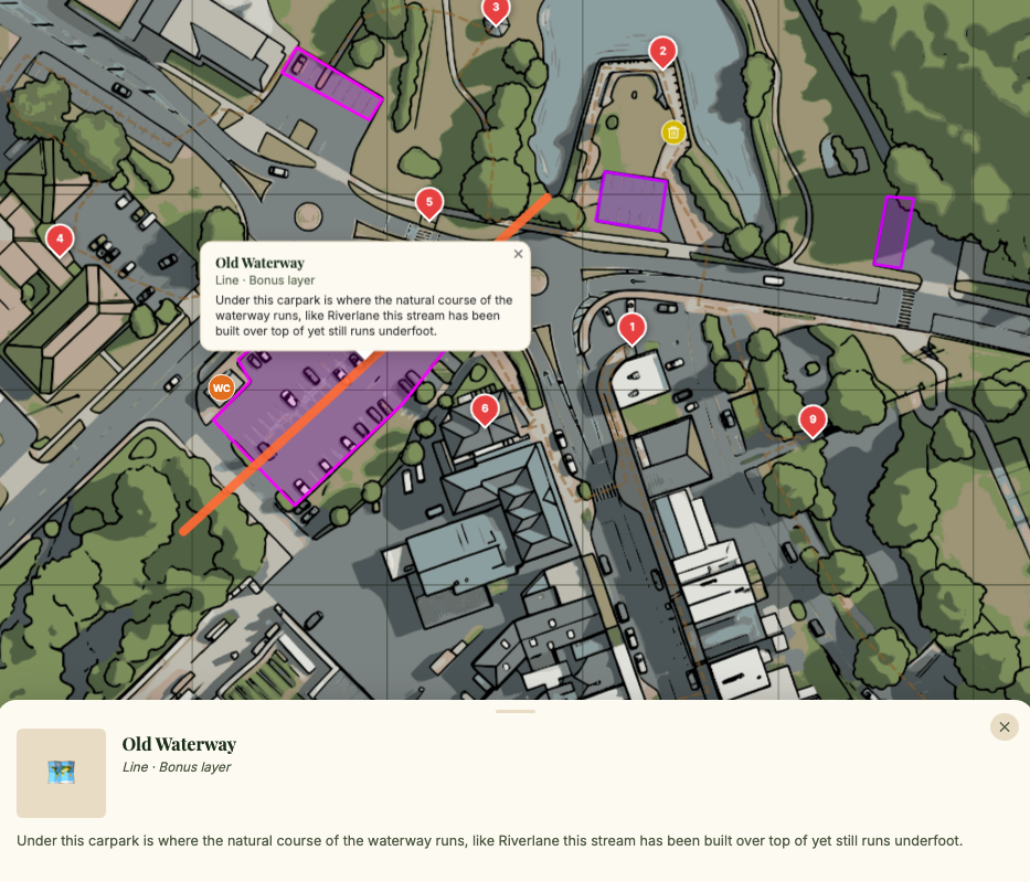
Draw Zones for carparks, private or public areas, footpath tracks and wetlands or planted areas.
Draw Lines for features or walls, boundaries, and “stay behind” lines.View Lines
Drop Notes on specific spots inside Zones or on Lines to record services, hazards, or instructions.
Assign Zones and Lines to Layers — one for food, one for clothing, another for public amenities or event areas.
Define Tour paths so visitors travel a set route, Pin-to-Pin.
Proximity triggers fire text, image and audio automatically — ideal for self-guided tours.
Search gives quick-find of any recorded item and highlights it on the map — great for markets, shops or public services.
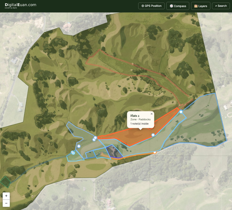
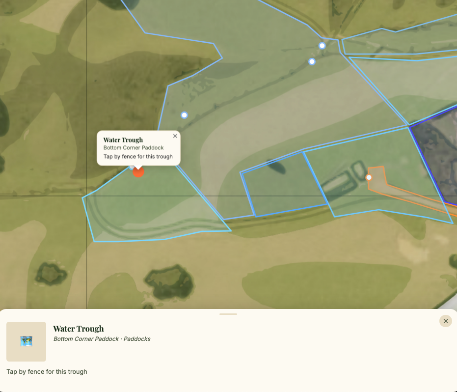
Property mapping with zones for paddocks, services and notes — showing how the same app scales to a larger rural footprint with farm-specific mapping needs.
Draw Zones for paddocks, farm or residential areas, farm tracks, and wetlands or planted areas.
Draw Lines for fences or waterlines, boundaries, and “stay behind” lines.
Drop Notes on specific spots inside Zones or on Lines to record services, hazards, instructions, or jobs to do and jobs completed.View Notes
Assign Zones and Lines to Layers — one for paddocks, one for farm tracks and roads, another for water or fences.
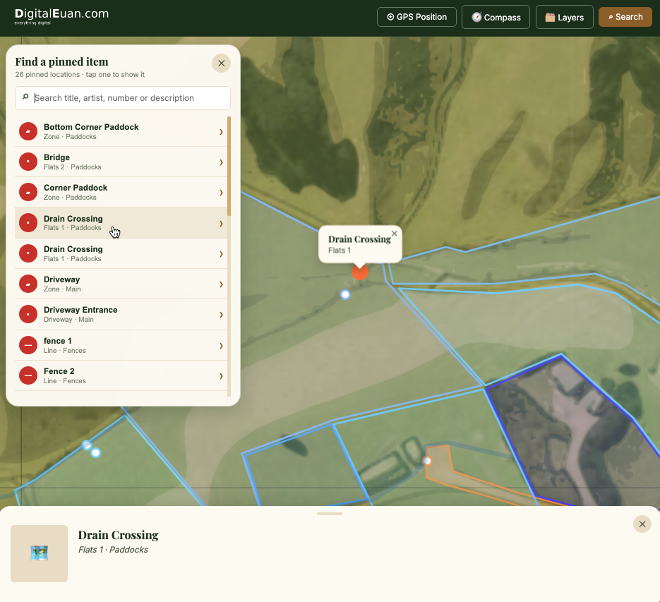
Search gives quick-find of any recorded item and highlights it on the map so it’s easy to find.View Search
Optional password protection keeps the map private — share the URL with a visitor, give them the password, and they instantly have the full app.
A complete guided-experience platform — maps, GPS, audio, admin, and print — all running natively in the visitor's browser. Here's what comes standard in every tier.
Interactive Custom Map
Upload your own aerial photo, illustrated map, or OS-style base. Supports 1×1 up to 12×12 tile grids — so anything from a single panel to a large multi-panel map. Locked GPS boundaries keep visitors on your trail.
Up to 12×12 grid
Live GPS Tracking
Real-time blue-dot positioning. When a visitor comes within an adjustable radius of a marked point, info and audio trigger automatically — no tapping required. User-alignable for pin-point accuracy on any device.
Standard 10 m trigger radius
Audio Guide System
Each trail stop can play its own MP3 audio guide automatically on proximity, or manually from the info panel. Persistent audio bar with progress, play/pause, and scrubbing. Browser autoplay policies handled gracefully.
MP3 / OGG
Smart Compass Mode
Map rotates to match the visitor's physical facing direction. A continuous requestAnimationFrame easing loop provides buttery-smooth rotation that always tracks the user's heading — no more jumpy 15° snapping. Pins and labels counter-rotate to stay upright. iOS permission prompt handled automatically.
Eased rAF smoothing
Guided Tour Mode
Step-by-step navigation through all items in pin-number order. Walking path drawn between current and next stops. Screen stays awake (Wake Lock API). Manual ‹ › buttons for self-paced exploration.
Wake Lock enabled
Multi-Layer Map Features
Group pins, Zones, Lines, and paths into named layers — "Main Trail", "Seasonal", "Heritage Walk". Visitors toggle layers on/off via the Layers button. Search shows only features on visible layers, while PDF Print and Tour mode respect layer selection.
Zones for Areas & Groups
Draw and name polygon Zones for keep-in/keep-out areas, gardens, lawns, farm paddocks, farm roads, concert platforms, market areas, or any other region. Add Zone Notes at specific locations inside a Zone, with text, images, audio, and links.
Lines for Routes & Services
Draw named, coloured Lines for fences, water, power, underground or overhead services, tracks, boundaries, or routes visitors should stay behind or follow. Lines are editable, layer-aware, clickable, searchable, and can be joined with other Lines.
New in this release
Admin Portal (CMS)
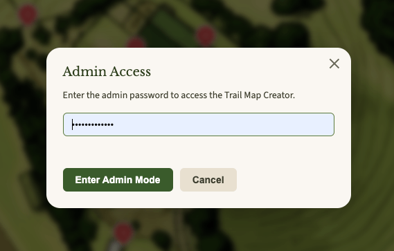
Hidden content management system with server-side password protection. Add, edit, and drag markers, draw walking paths, upload tiles, manage layers, configure settings — all from a browser, no coding required. The admin password lives only in a server-side PHP file and your browser — never in any public JavaScript.
No-code CMS
Direct-to-Server Saves
Edit your trail in the admin portal, then click "Save to Server" — changes go live instantly. No downloading files and re-uploading via File Manager. A backup of the previous data is created automatically on every save, so you can always roll back.
Instant publishing
Click-to-Enlarge Images
Tap any thumbnail in the item info panel, Start Tour view, or admin list to see it full-size in a lightbox. Great for reading plaque text or admiring artwork detail. Closes with a tap, Escape key, or the ✕ button. Keyboard accessible.
Lightbox viewer
A3 PDF Map Export
For Admin - generate print-quality A3 trail maps with your logo, numbered markers, thumbnails and pinned item information. Layer selector lets you choose which layers print. Smart sizing auto-fits any tile-grid aspect ratio. Much easier to keep printed maps up to date.
260 DPI capture
Live Audio Streaming
Connect an Icecast stream to run live guided tours or events. Visitors tap "Live Tour" in the header to hear real-time commentary. Auto-suppresses GPS-triggered audio to prevent conflicts.
Icecast compatible
Public Map Password
Optionally password-protect your trail. Visitors enter a password before the map loads. Perfect for member-only trails, paid attractions, or works-in-progress.
Optional gate
Auto Update Notifications
The admin panel silently checks for new versions and shows a dismissible banner when an update is available — with download link, changelog, and update instructions. Your installation never falls behind.
New in this release
Anti-Copy Protection
Deterrent-level protection: right-click, text selection, keyboard shortcuts, image drag, and iframe embedding are all blocked on the public map. Toast notifications educate without annoying. All toggleable in config.
Deterrent tier
Search Pins, Zones & Lines
The optional "⌕ Search" control opens a searchable list of visible marked items, toilets, rubbish bins, Zones, Zone Notes, and Lines. Search matches names, descriptions, titles, artists, dates, and layers. Selecting a result centres the map and opens its linked detail panel.
Deterrent tier
Dark Mode
Visitors tap the 🌙 button for a purpose-built dark palette — easier on the eyes for evening walks and kinder to the battery on OLED screens. The choice is remembered on each device, the app repaints instantly with no white flash on load, and the whole look can be recoloured to match your brand. Offer or hide the button per location from Admin → Settings, just like every other menu item.
New in v4.4.0
Multiple Locations (Multi-Map)
One core system, many trails. Create additional map locations from the same admin portal (🗺 Maps) — each gets its own folder on your hosting with separate tiles, images, audio, and data. Visitors swap between locations with the 🗺 Switch Map button, and every location keeps its own pins, layers, settings, and password. Perfect for councils and multi-site operators — no code duplicated, ever.
New in v4.4.0
Process
From brief to live real fast! not months.
No app store approval. No ongoing developer dependency. Pick the tier that matches your project's capacity — we handle the rest.
1
Choose your tier
Self-setup, we-set-it-up or full map-making service - or just talk to us about what you want. Every tier gets the full app — the difference is how much we do for you.
2
Share your content
Map image (or commission one from us), GPS coordinates, photos of each stop, descriptions and optional audio. We provide a clear checklist.
3
We configure & brand
Your logo, colours, and text are applied. Markers positioned. Audio linked. Map bounds calibrated. Hosted on your domain — your visitors never leave your site.
4
Review & approve
We send a preview link. Test on your phone, walk the trail, confirm everything's right. Revision rounds included per your tier.
5
Go live — instantly
Your trail is live at your domain (e.g. yoursite.co.nz/trail). Share the link on signage, website, social, and printed materials. Visitors just open it in their browser.
!
Easy Base-Map Maker
Custom built tool for this app to capture base maps and the GPS bounds the App needs + a tool for splitting and naming Tiles for this app!
***
Admin Portal
Password protected Admin portal for adding, editing, adjusting, A3 PDF creation and more.
Who it's for
Built for organisations with a story to tell.
Any organisation with a physical route, collection, or points of interest can have a professional digital trail app. Here are some common fits.
Sculpture & Art Trails
Councils, trusts, and galleries running outdoor exhibitions and permanent public art collections.
High value
Heritage & History Walks
Local history societies, heritage trusts, and town councils preserving and sharing community stories.
Community
Nature & Wildlife Reserves
Conservation organisations, regional parks, nature reserves, and wildlife sanctuaries with educational trails.
Educational
Town & Tourism Trails
Visitor centres, Business Improvement Districts, and tourism boards driving footfall with curated walking routes.
Tourism
Festivals & Events
Outdoor art festivals, food trails, open garden days, and markets needing a temporary digital trail experience.
Seasonal
Campus & School Tours
Universities, colleges, and schools offering self-guided orientation, open day, or nature education trails.
Institutional
Farm & Agritourism
Farm parks, vineyards, orchards, and rural attractions enhancing visitor exploration and dwell time.
Rural
Museums & Galleries
Indoor and outdoor collections needing guided tours — keeps your printed leaflet up to date or replaces it.
Cultural
See it live on your phone right now.
The fully working trail app is live at the link below. Experience exactly what your visitors will see.
👆 Tap to open in browser · Works on iPhone and Android · No download required
Pricing
Simple, transparent pricing.
One-time setup fee to get you live. Small annual licence keeps updates and support flowing. No surprises, no hidden costs.
Every tier includes the full app + free updates.The difference is how much setup work we do for you — not which features you get. GPS, audio, compass, PDF export, layers, dark mode, multiple locations, admin portal, anti-copy, password protection: all included from Tier 1.
Tier 1
Self-Setup
NZ$595
+ NZ$65 / year licence
You fill in the content
✓ Full Guided Trail System app
✓ Free app updates
✓ Unlimited trail stops capacity (you are adding them)
All prices in NZD. Annual licence renews to maintain app updates and support.
Tier 3 GPS work is Auckland-region by default.
Content updates beyond included revisions charged at NZ$120/hour.
Always included
No matter which tier, you get the full app.
The tiers differ only in how much setup work we do for you. The app itself is identical across every tier — these features ship as standard.
✓
Interactive map with 1×1 to 12×12 tile grid
✓
Live GPS tracking with adjustable proximity trigger
✓
Audio guide system with auto-play on approach
✓
Compass mode with sensor smoothing
✓
Guided tour mode with wake lock
✓
Multi-layer trail map with pins, Zones, Lines, paths, and visitor toggle
✓
Dark mode — per-device visitor toggle, admin-controlled
✓
Multiple locations — many maps, one core system, one admin portal
✓
Zones & Zone Notes for areas, groups, and rich location details
✓
Named coloured Lines for fences, tracks, utilities, and service routes
Direct-to-server saves — instant publishing from admin
✓
Image lightbox — click-to-enlarge on all thumbnails
✓
Server-side password protection — no password in public files
✓
Hosted on your domain (no third-party URLs)
✓
Free app updates — never falls behind
Frequently asked
Good questions, straight answers.
- You need somewhere on the internet to put the app - so visitors can reach them via a URL (website address) - basically you need a domain name and a hosting plan to store the app. Most commonly this is: cPanel hosting - you log in to a control panel and use "File Manager" to upload files. FTP access - if your host doesn't have cPanel, you can use a free FTP program like FileZilla or Cyberduck to upload files..
- Modern browsers block GPS location on non-HTTPS pages. If your site loads as http:// instead of https:// the GPS features will not work
- Website builder platforms (Wix, Squarespace, Shopify) don't work with this app. The Guided Trail System needs traditional file-based hosting.
- PHP is required for the "Save to Server" feature (which lets you publish changes instantly from the admin portal). Virtually all cPanel/shared hosting includes PHP. If your host doesn't support PHP, you can still use the app — you'll just use the Publish (download ZIP) workflow instead.
- Yes, we can help with uploading and setup
Yes. Your admin password is never stored in any public file. It lives in exactly two places: (1) a server-side PHP file (save.php) which runs on the server and is never sent to the browser, and (2) your browser's local storage after you log in. Even if someone views your page source or downloads your JavaScript files, they cannot see the password.
The save.php endpoint is also protected by an .htaccess rule that blocks direct browser access — only POST requests from the admin portal are accepted. The password is compared in constant time to resist timing attacks.
No. The Guided Trail System is a Web App that runs entirely in the browser. Visitors just open a URL on their phone — the experience works instantly on iPhone, Android, or desktop. They can optionally "Add to Home Screen" for a native-app-like icon, but this is not required.
The app is hosted on your own domain (e.g. yoursite.co.nz/trail) — your visitors never leave your website. All trail data lives in a single JSON file on your hosting. Audio and image files live in your own /audio/ and /images/ folders. Nothing is sent to third parties.
The only external call the app makes is the update-check (admin side only) which fetches a small manifest from digitaleuan.com to see if a new version is available. This sends no data about your installation.
Tier 1 (Self-Setup) — You get the full app and fill in your own content via the admin portal. We provide a 1-hour setup video call to walk you through it + full instructions (it isn't difficult).
Tier 2 (We Set It Up) — You supply your data (map image, GPS coords, photos, descriptions, audio) and we configure the entire app, calibrate GPS, apply branding, and with you to install the app on your hosting.
Tier 3 (Full Service) — Everything in Tier 2, plus we create the custom map illustration for you (Auckland region: we source the base map; NZ-wide: you supply the base and we illustrate).
No — the app requires an active internet connection to load map tiles, audio files, and trail data. Most NZ trail locations have mobile coverage, but if yours doesn't, get in touch and we can discuss options.
App updates are free, in every tier. When a new version is released, your admin panel automatically shows a banner with a download link and changelog. You download the ZIP, back up your /trail folder, and upload the new files via your hosting's File Manager. The whole process takes about 5 minutes.
Your trail data, images, and audio are never touched by app updates.
The annual licence covers: (a) access to app updates as they're released, (b) the update-notification service (your admin panel checks digitaleuan.com for new versions), and (c) email support for technical questions. It does not cover content updates — you can edit your own content via the admin portal/upload to hosting for free at any time, or commission us to do it at NZ$120/hour.
If you cancel the licence, your app continues to work — you just stop receiving support.
Yes. iOS Safari is fully supported including "Add to Home Screen" for a standalone experience. The only iOS-specific quirk is compass mode — iOS 13+ requires an explicit permission grant, which the app handles automatically with a prompt on first activation.
Audio autoplay is restricted on all mobile browsers (Apple policy). The app handles this gracefully by "arming" the audio context on first user interaction, then auto-playing on subsequent GPS triggers.
Yes — the admin portal lets you enable optional password protection on the public map. Visitors must enter the password (SHA-256 hashed) before the map loads. This is perfect for member-only trails, paid attractions, or works-in-progress. The password is set in Admin → Settings → Public Map Password, and is separate from your admin password.
Note: this is deterrent-level protection only, since the check happens client-side. For true server-side protection, your web host can add HTTP Basic Auth on the /trail/ folder.
Yes. Since v4.4.0 the app supports multiple locations: each location is a complete map with its own tiles, images, audio, and data, stored in its own folder on your hosting — all managed from the one admin portal (the 🗺 Maps button). Nothing about the core system is duplicated, so adding a second or tenth location doesn't multiply your maintenance.
Visitors swap between locations with the 🗺 Switch Map button in the app menu, and you can link or QR-code directly to any location (yoursite.co.nz/trail/?map=river-walk). Every location has its own pins, layers, settings, and optional public password. If you only need one map, everything works exactly as before — the switcher simply never appears.
Yes. Visitors can toggle dark mode with the 🌙 button in the app menu — a full dark palette that's easier on the eyes for evening walks and kinder to the battery on OLED screens. Their choice is remembered on their device and restored on every visit, with no white flash while the app loads.
As the trail operator, you decide whether the button is offered at all — it's controlled per location in Admin → Settings, exactly like the Live Tour, Search, and Layers buttons. The dark palette can also be recoloured to match your branding from config.js.
Book a consultation to scope your requirements. Custom feature development is quoted per project, and you have the option of full source-code access so your in-house team can maintain it long-term.
Get in touch
Ready to talk? Let's build your trail.
Book a free 20-minute call, request a custom quote, or ask any questions. We respond within one NZ business day.
Let's build your trail.
Whether you're a small sculpture trail committee or a regional council looking to deploy across multiple sites, we'll find the right tier for you. Open the live demo on your phone first — then get in touch and let's talk about your project.
 View Lines